Jilin University’s Gravity and Magnetic Field Artificial Intelligence Team吉林大学重磁人工智能团队
周帅
赵建维
林 涛
贾宏发
贾建豪
姚秀安
陈伊佳
娄凤博
王学崇
郭颖明
张 铭
Shuai Zhou
Jianwei Zhao
Tao Lin
Hongfa Jia
Jianghao Jia
Xiuan Yao
Yijia Chen
Fengbo Lou
Xuechong Wang
Yingming Guo
Ming Zhang
College of Geo-Exploration Science and Technology, Jilin University, Changchun
吉林大学 地球探测科学与技术学院,中国 长春
🚧 Over the past five years, the team has focused on the exploration needs
related to underground JS facilities, unexploded ordnance detection, QT detection, exploration of high-risk mines,
and new energy sources such as geothermal energy and natural gas hydrates. It has led four projects and
sub-projects under the National Key Research and Development Program, two projects under the JW Science and
Technology Commission, two grants from the National Natural Science Foundation of China (General and Young
Investigator programs), two grants from the Jilin Provincial Department of Science and Technology, two grants from
the Postdoctoral Science Foundation, and two projects from the State Oceanic Administration, with a total budget
of over 15 million.The team has published more than 30 high-quality SCI papers, obtained 4 authorized invention
patents and more than 10 software copyrights, and received one Second Prize for Scientific and Technological
Progress from the Chinese Geophysical Society and one Second Prize for Scientific and Technological Progress from
the Ministry of Natural Resources.团队近5年来围绕地下JS设施探测、未爆炸探测、QT探测、危机矿山勘探、地热、天然气水合物等新型能源勘探需求,主持国家重点研发计划课题和子课题4项、JW科技委项目2项、国家自然科学基金2项(面上、青年)、吉林省科技厅基金2项、博士后科学基金2项、国家海洋局项目2项,可支配经费超过1500万。以发表高水平SCI论文30余篇,授权发明专利4项,软件著作权10余项,获得中国地球物理协会科学技术进步二等奖1项,自然资源部科学技术进步二等奖。
Basic Sample Database and Intelligent Inversion for Multi-Factor Gravity and Magnetic
Intelligent Inversion
多要素重力磁力智能反演基础样本库与智能反演
Abstract摘要
The project focuses on research into key issues in multi-factor, high-magnetic-field
intelligent inversion.It proposes a composite intelligent inversion theoretical framework consisting of a
“data sample network + physical model network,” which enables joint inversion of multi-source, multi-scale,
and multi-parameter data through mechanisms such as dynamic information fusion. Ultimately, the project
independently developed a gravity and magnetic inversion imaging software platform capable of large-scale
industry-wide deployment, facilitating the sharing of research results andindustry-wide
adoption.项目围绕多要素重磁智能反演关键问题开展研究。提出“数据样本网络+物理模型网络”的复合智能反演理论框架,通过动态信息融合机制等实现多源数据联合反演实现多源、多尺度、多参数联合反演;最终自主研发具有行业规模化推广应用能力的重磁反演成像软件平台,实现成果共享与行业推广。
Network Architecture of a Composite Intelligent Inverse Physical U-Net
Model复合智能反演物理U-Net模型网络架构
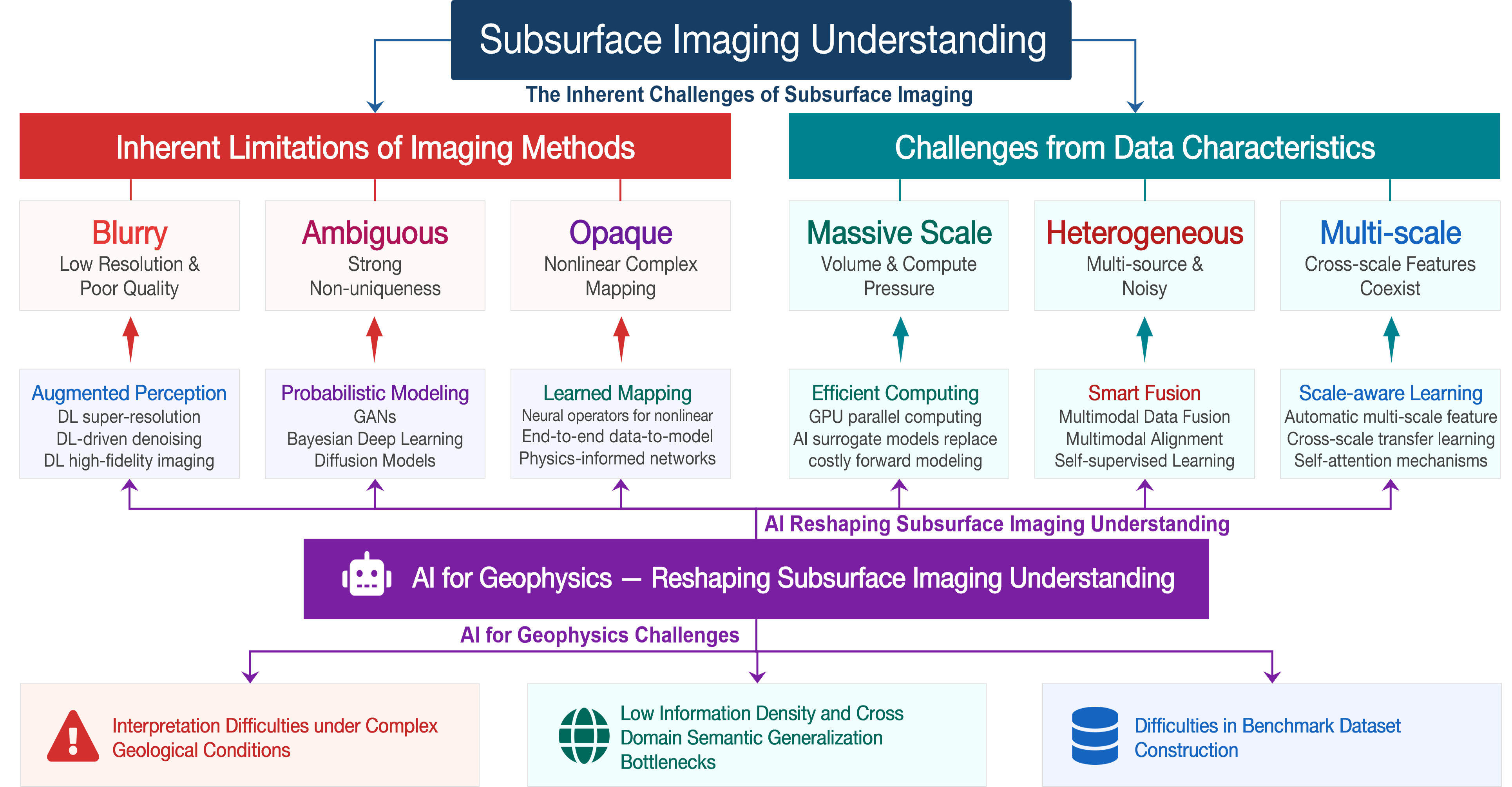
An AI Framework for Subsurface Imaging面向地下成像的 AI 框架
A structured overview of AI for geophysics-based subsurface imaging
understanding, and why subsurface data make machine learning harder than in natural or medical
imaging.对面向地球物理地下成像理解的 AI 进行结构化梳理,并阐释为何地下数据使机器学习比自然图像或医学影像更具挑战性。
An AI framework for geophysics-based subsurface imaging
understanding: core challenges and AI-driven solutions. 面向地球物理地下成像理解的 AI
框架:核心挑战与 AI 驱动的解决方案。
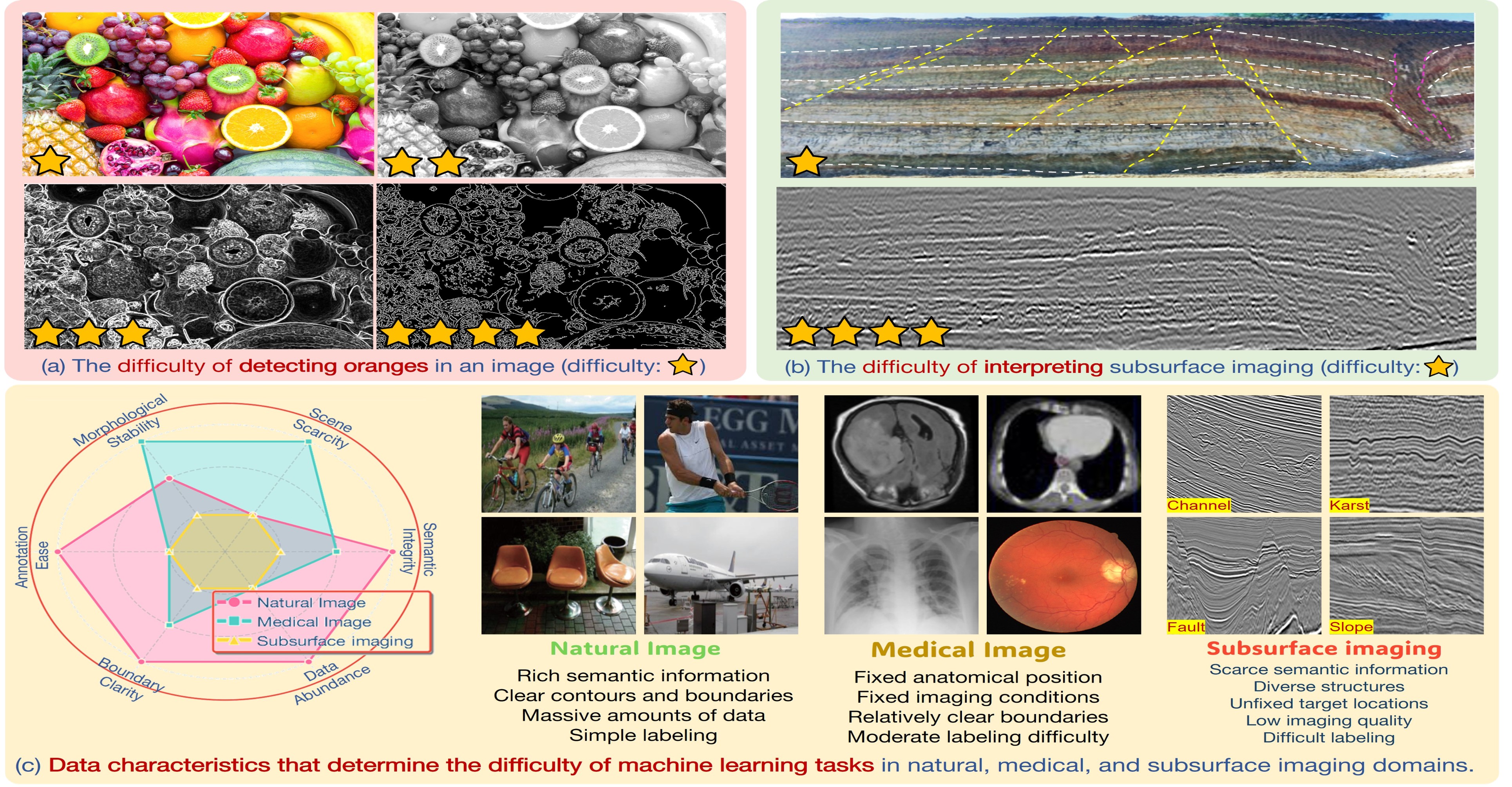
Figure 2. Why subsurface imaging is harder for
machine learning than natural and medical imaging.
为何地下成像相比自然图像与医学影像对机器学习更具挑战性。
Key Contributions主要贡献
1
Decade-spanning survey of 652 publications across four subsurface
interpretation directions, with citation-network analysis that reveals cross-domain knowledge flow and
methodological evolution from seismic attributes to domain foundation models.建立国内外首套多要素重磁智能反演基础样本库
2
Systematic task-wise review of deep-learning methods across structure,
geobody, facies, and property tasks, tracing each evolutionary trajectory and identifying the remaining
bottlenecks for cross-survey generalization.提出"数据样本网络+物理模型网络"复合智能反演理论
3
CIG-Bench open-source library: pretrained baselines for fault, RGT,
channel, karst, and property tasks with cross-survey transferability, plus one-click
pip install inference APIs that load weights automatically from ModelScope, with one-line
dataset downloads.实现多源重磁数据联合反演
4
Long-term, community-maintained ecosystem: standardized splits and
metrics, continuous model updates, and a roadmap for integrating community-contributed baselines and new
tasks as the field evolves.实现样本库、模型库和软件平台开源共享
Interpretation Tasks解释任务
Subsurface interpretation is decomposed into four conceptually
overlapping but methodologically distinct categories.地下解释被分解为概念上相互重叠、但方法学上各有侧重的四类任务。
🏗️
Structure构造
Faults, horizons, unconformities, and relative geologic time (RGT) for constructing
structural frameworks and stratigraphic models.断层、层位、不整合面与相对地质年代
(RGT),用于构建构造格架与地层模型。
🪨
Geobody地质体
3D segmentation of salt bodies, channels, karst cavities, and igneous intrusions with
relatively independent geometries.对盐体、河道、岩溶洞穴与岩浆侵入体等具有相对独立几何形态的目标进行三维分割。
📊
Facies地震相
Classification of seismic units by amplitude, frequency, continuity, and
stratification — reflecting depositional environments.依据振幅、频率、连续性与层理对地震单元进行分类——反映沉积环境。
🔬
Property属性
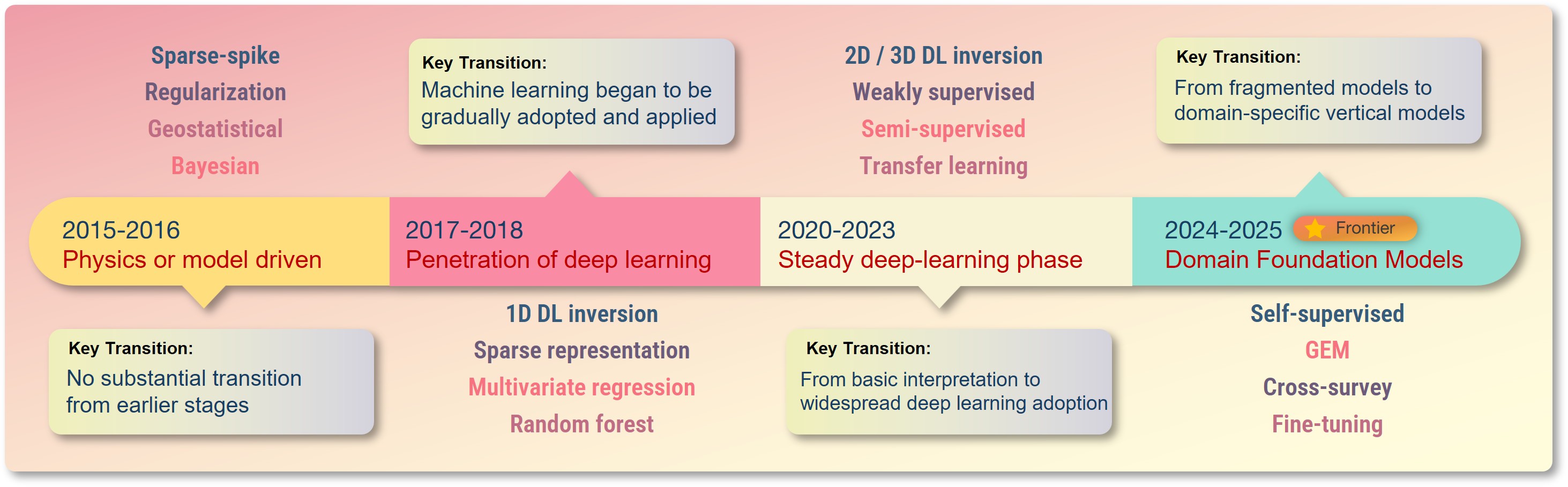
Inversion of impedance, velocity, porosity, density, and Vp from seismic data
calibrated with sparse well logs.利用稀疏测井标定,从地震数据反演阻抗、速度、孔隙度、密度与纵波速度
(Vp)。
Evolution of Research Paradigms研究范式的演进
Click tabs or use arrows to explore the decade-long evolution of each
task category.点击标签页或使用箭头,探索各任务类别跨越十年的演进历程。
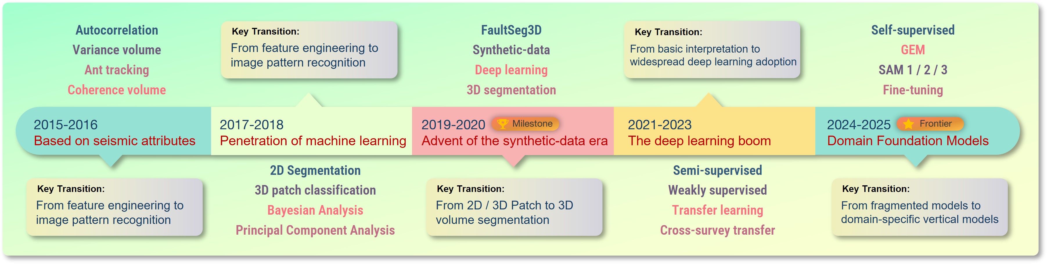
Seismic attributes (2015–16) → ML penetration with 2D
segmentation and patch-based classification (2017–18) → synthetic-data era and 3D deep segmentation
(FaultSeg3D, 2019–20) → semi-/weak supervision (2021–23) → domain foundation models (GEM/SAM,
2024–25). 地震属性 (2015–16) → 机器学习渗透,二维分割与基于图块的分类 (2017–18) → 合成数据时代与三维深度分割
(FaultSeg3D,2019–20) → 半监督/弱监督 (2021–23) → 领域基础模型 (GEM/SAM,2024–25)。
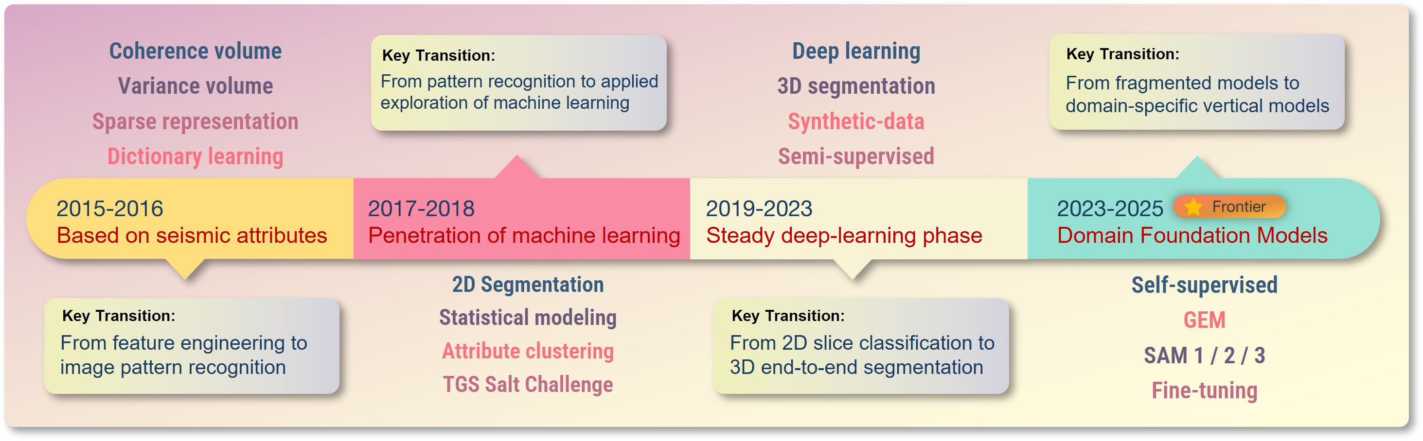
Multiscale attribute enhancement → TGS Salt Challenge and
supervised 2D segmentation → 3D end-to-end volumetric segmentation with synthetic and semi-supervised
training → SAM-style prompting and unified foundation frameworks (GEM).
多尺度属性增强 → TGS 盐丘挑战赛与有监督二维分割 → 结合合成数据与半监督训练的三维端到端体分割 → SAM 式提示与统一基础框架 (GEM)。
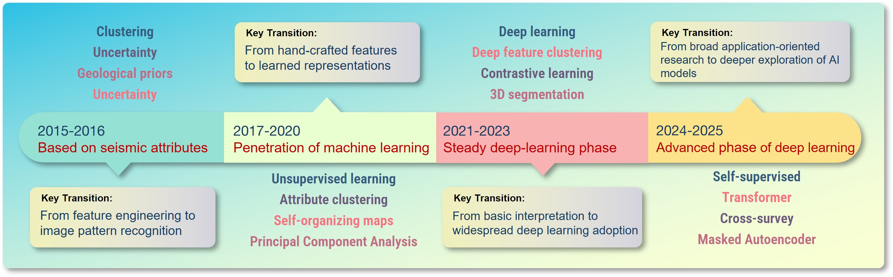
Attribute-based clustering and SOM → deep feature clustering and
contrastive learning → self-supervised pretraining and cross-survey generalization with horizon-based
and sectional viewing paradigms. 基于属性的聚类与 SOM → 深度特征聚类与对比学习 →
自监督预训练,以及基于层位与剖面观察范式的跨工区泛化。
One-line install. One-line dataset download. Five predictors. Weights
downloaded automatically on first call. Each task is paired with an example result on real field
data.一行命令安装。一行代码下载数据集。五个预测器。首次调用时自动下载权重。每个任务都配有在真实野外数据上的示例结果。
from cig_bench.dataset importcig_structureData, cig_geobodyData# One line each — downloads the subset into a directory you choose# and returns its local path. Two subsets: Structure and Geobody.
structure_dir = cig_structureData("./CIG-Bench-Dataset") # -> ./CIG-Bench-Dataset/Structure
geobody_dir = cig_geobodyData("./CIG-Bench-Dataset") # -> ./CIG-Bench-Dataset/Geobody
🏗️ Fault segmentation断层分割
from cig_bench.predictor.fault importFaultPredictor
fault_predictor = FaultPredictor(device="cuda")
prob, used = fault_predictor.predict(
seis, # (tline,iline,xline)
rank=4, chunk_size=64, # memory-bounded chunked inference
threshold=0.5,
scale_t=0.5, scale_h=0.85, scale_w=0.85,
resize_back=True, # return result at the original (T, H, W)
)
fault_predictor.visualize(used, prob)
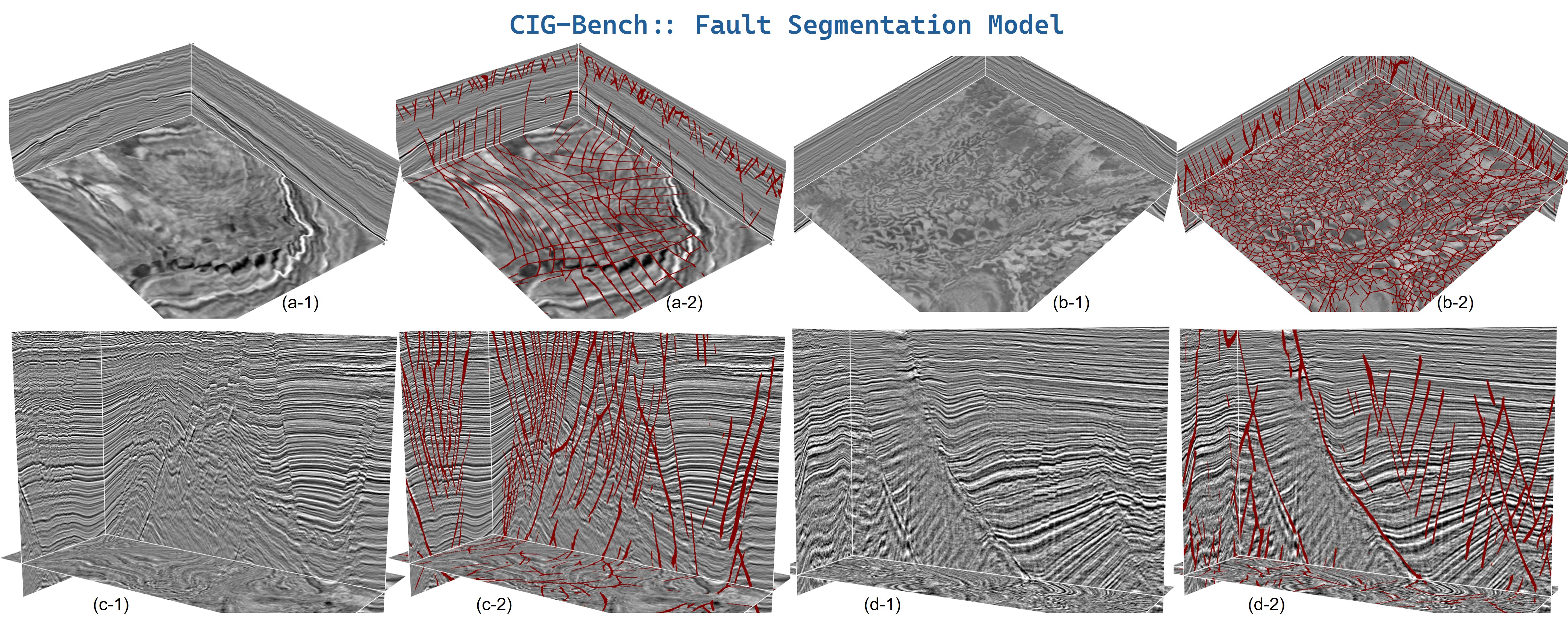
Example result · Fault. Fault segmentation on four
field surveys (a–d): the input seismic (columns *-1) and the predicted faults rendered
in red over the seismic (columns *-2), shown on crossline-style cubes (a, b) and
inline sections (c, d). The model resolves subtle polygonal faults, extremely dense intersecting
networks, and deep-rooted dipping planes with associated secondary faults.
在四个野外工区 (a–d) 上的断层分割:输入地震数据(*-1 列)与以红色叠加在地震上的预测断层(*-2 列),分别以联络测线式数据体
(a, b) 与主测线剖面 (c, d) 展示。模型能够刻画细微的多边形断层、极其密集的交叉断层网络,以及深部根植的倾斜断面及其伴生的次级断层。
⏱️ Relative Geologic Time (RGT) estimation相对地质年代 (RGT) 估计
from cig_bench.predictor.rgt importRGTPredictor
rgt_predictor = RGTPredictor(device="cuda")
rgt_vol, used = rgt_predictor.predict(seis) # (tline,iline,xline)
horizons = rgt_predictor.extract_horizons(rgt_vol, n_horizons=100)
rgt_predictor.visualize(used, rgt_vol, horizons)
# visualize() also auto-traces horizons when none are passed:# rgt_predictor.visualize(used, rgt_vol)
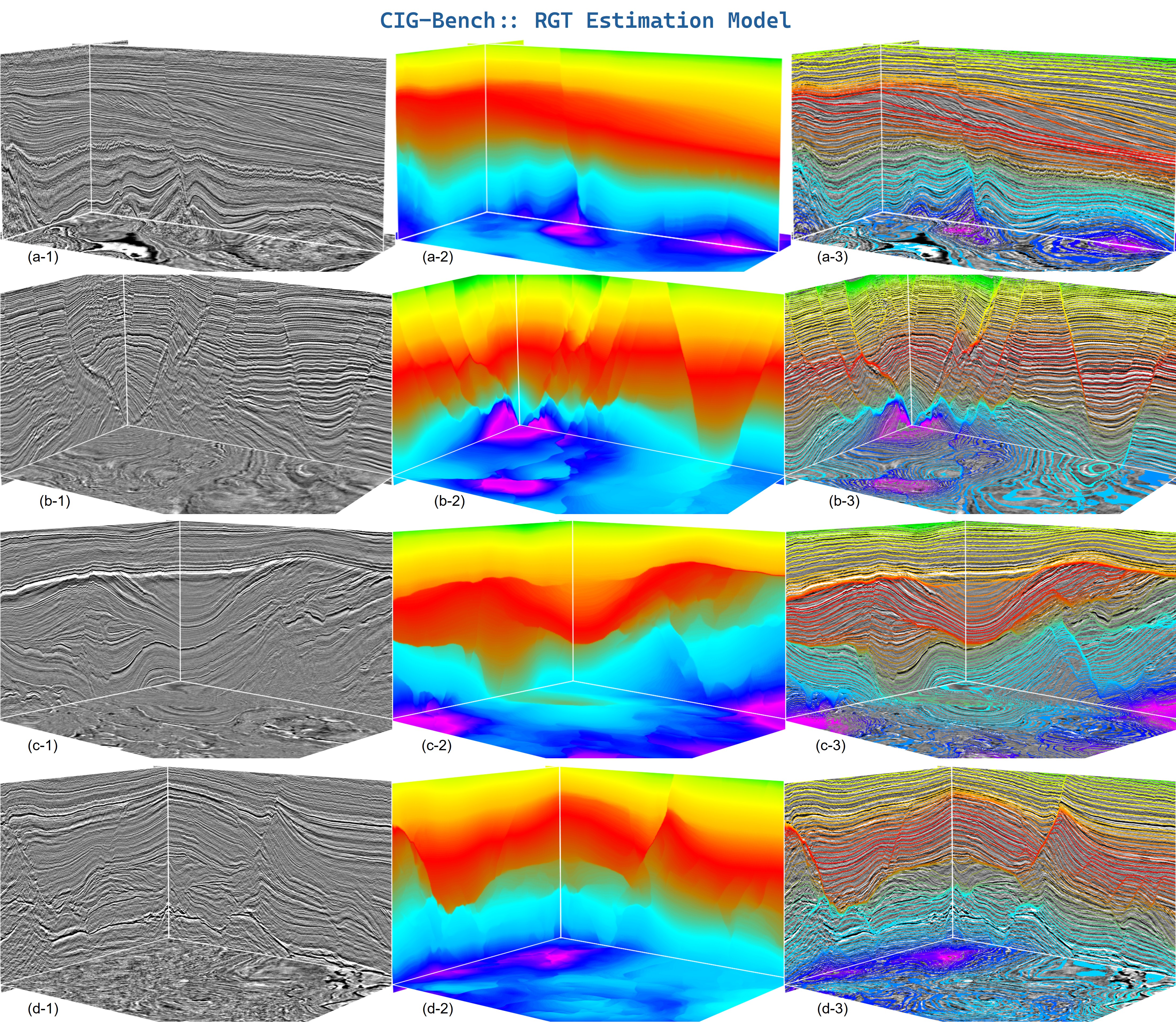
Example result · RGT. Relative-geologic-time
estimation on four field surveys (a–d): input seismic (*-1), the regressed RGT volume
(*-2), and horizons extracted from the RGT volume and overlaid on the seismic
(*-3). Predictions stay smooth and stratigraphically consistent across slope bodies,
unconformities, densely faulted zones, and multi-package stratigraphy.
在四个野外工区 (a–d) 上的相对地质年代估计:输入地震数据(*-1)、回归得到的 RGT 体(*-2),以及从 RGT
体中提取并叠加到地震上的层位(*-3)。在斜坡体、不整合面、密集断裂带与多套地层组合中,预测结果均保持平滑且地层一致。
from cig_bench.predictor.channel importChannelPredictor
channel_predictor = ChannelPredictor(device="cuda")
scores, used = channel_predictor.predict(
seis, # (tline,iline,xline)
scales=[0.5, 0.75, 1.0, 1.25, 1.5], # custom scale set
accumulate="sum",
)
mask = channel_predictor.postprocess(scores, threshold=0.75, min_size=50000)
channel_predictor.visualize(used, scores, mask)
# The karst predictor is used identically — only the checkpoint changes:from cig_bench.predictor.karst importKarstPredictor
karst_predictor = KarstPredictor(device="cuda")
scores, used = karst_predictor.predict(seis) # (tline,iline,xline)
mask = karst_predictor.postprocess(scores, threshold=0.75)
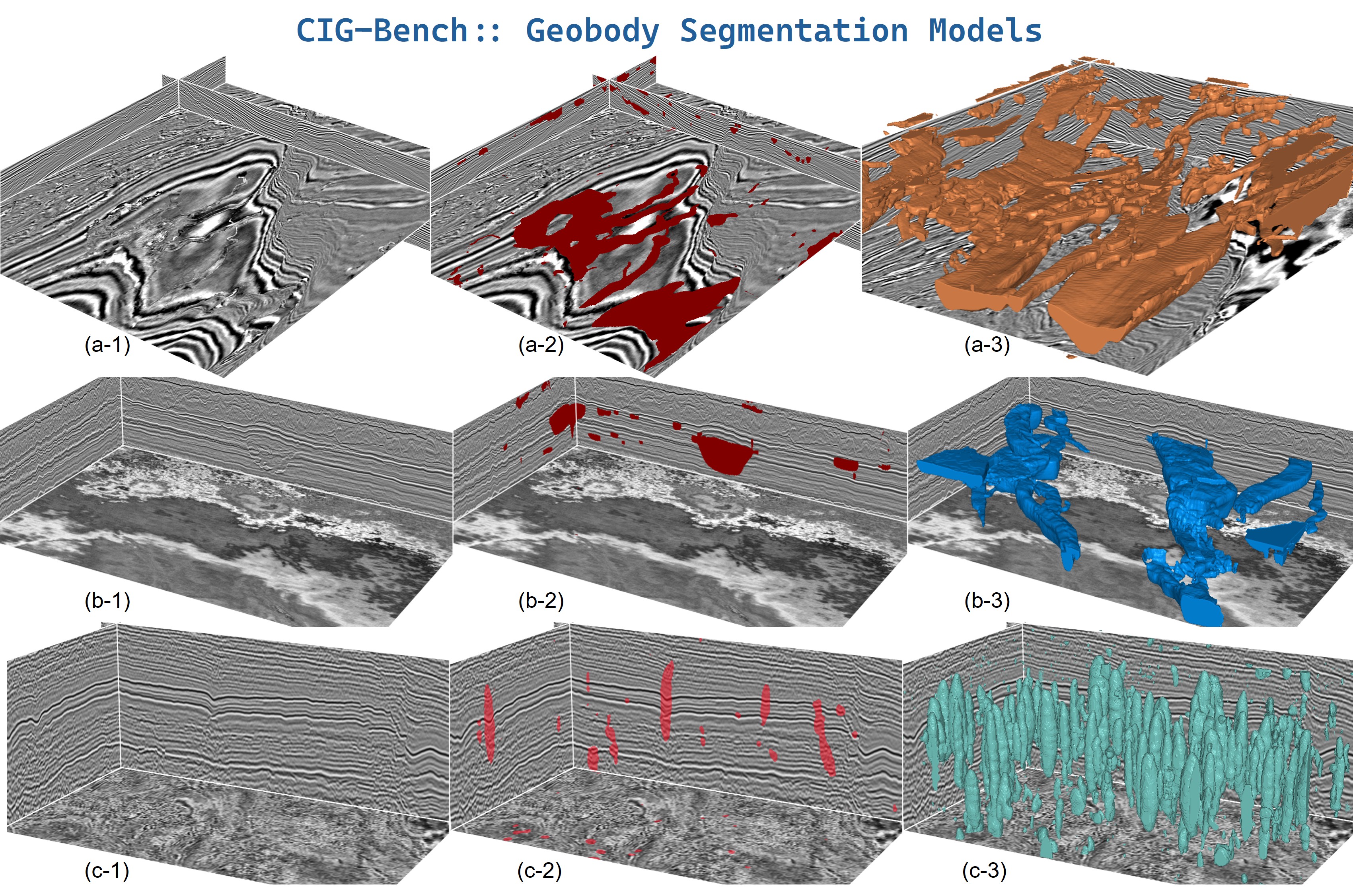
Example result · Channel / Karst. Geobody
segmentation on three field examples (rows a–c): input seismic (*-1), the predicted
probability overlaid on the seismic (*-2), and the extracted 3D geobody surface
(*-3) after thresholding and connected-component cleanup. (a, b) channel systems and
(c) karst-cave systems. 在三个野外示例(a–c
行)上的地质体分割:输入地震数据(*-1)、叠加在地震上的预测概率(*-2),以及经阈值化与连通域清理后提取的三维地质体表面(*-3)。(a,
b) 为河道体系,(c) 为岩溶洞穴体系。
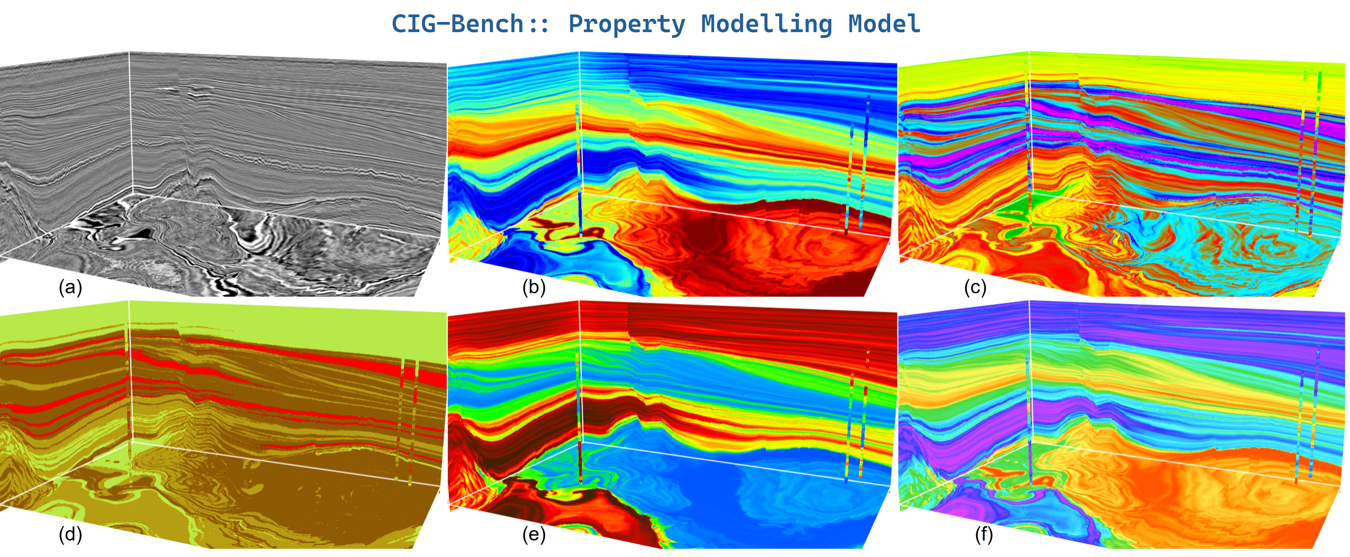
Example result · Property. Property modeling under
the promptable conditional paradigm with seismic + sparse well-log inputs. (a) input seismic;
(b–f) dense 3D property volumes predicted from the seismic conditioned on sparse well logs (the
thin vertical strips are the conditioning wells) — e.g. acoustic impedance, gamma-ray, lithology, sonic,
and Vp. Predictions stay coherent with the seismic reflection patterns despite spatially sparse well
constraints. 在可提示的条件建模范式下,以地震 + 稀疏测井为输入的属性建模。(a) 输入地震;(b–f)
以稀疏测井为条件、从地震预测得到的稠密三维属性体(细的垂直条带为作为条件的井)——例如声波阻抗、伽马、岩性、声波时差与纵波速度 (Vp)。尽管井约束在空间上稀疏,预测结果仍与地震反射模式保持一致。
Weights download automatically on first use from ModelScope.
Datasets download with one line: from cig_bench.dataset import cig_structureData, cig_geobodyData.权重在首次使用时自动从 ModelScope 下载。
数据集一行代码下载:from cig_bench.dataset import cig_structureData, cig_geobodyData。
Citation引用
If you
find this survey or benchmark useful, please cite our work:如果本综述或基准对您有帮助,请引用我们的工作:
@article{dou2026cigbench,
  title         = {CIG-Bench: A Comprehensive Survey and Benchmark for AI-Driven Subsurface Imaging Understanding},
  author        = {Yimin Dou and Xinming Wu and Hui Gao and Mingliang Liu and
                   Tao Zhao and Zhi Zhong and Haibin Di and Min Jun Park and
                   Robert G. Clapp and Zhixiang Guo and Long Han and Sergey Fomel},
  journal       = {arXiv preprint arXiv:2606.09094},
  year          = {2026},
  eprint        = {2606.09094},
  archivePrefix = {arXiv},
  doi           = {10.48550/arXiv.2606.09094},
  url           = {https://arxiv.org/abs/2606.09094}
}